For the 2025 Atlantic hurricane season, Lorenzo will be the 12th named storm. The name Lorenzo has been used for multiple tropical cyclones in the Atlantic Basin, including both Tropical Storm Lorenzo and Hurricane Lorenzo in different years.
Below, we’ll provide an overview of each storm’s origin, path, and impact, along with comparisons of their meteorological characteristics to better understand their legacy.
Understanding the History of Lorenzo
Tropical Storm Lorenzo (2001)
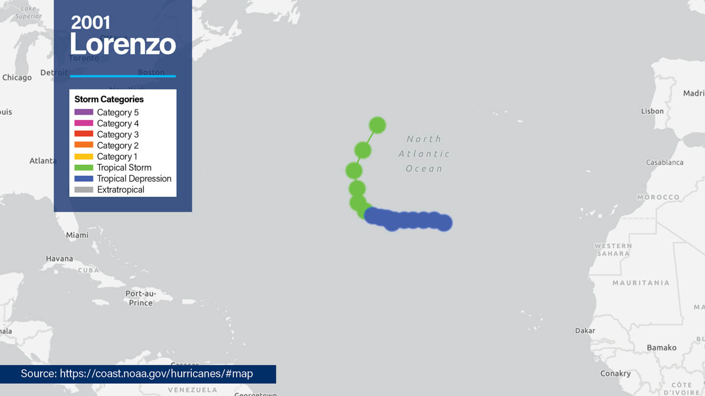
- Formation: 2001 Tropical Storm Lorenzo formed from a tropical weather system over the eastern North Atlantic on October 27, 2001. It maintained tropical storm strength for only 30 hours, with maximum sustained winds of approximately 40 mph (35 knots) and a central pressure of 1007 millibars, until it merged with a frontal system west of the Azores after beginning its dissipation phase.
- Impact: Fortunately, the storm remained primarily a maritime threat, without any fatalities or notable damage.
Hurricane Lorenzo (2007)
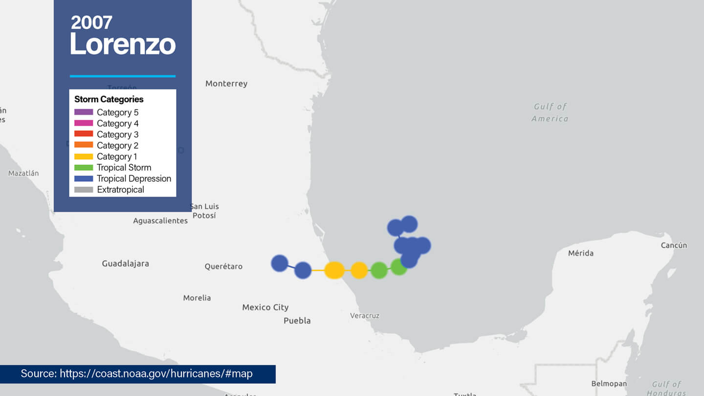
- Formation: 2007 Hurricane Lorenzo developed from a tropical wave on the Gulf Coast, achieving maximum sustained winds of 80 mph (70 knots) and 990 millibars. It made landfall near Tecolutla, Mexico, on September 28, 2007, as a Category 1 hurricane.
- Impact: Heavy rainfall exceeding 12 inches caused flash floods and landslides in Veracruz and Puebla. Prolonged power outages and severe damage in local towns compounded the storm’s aftermath.
Tropical Storm Lorenzo (2013)
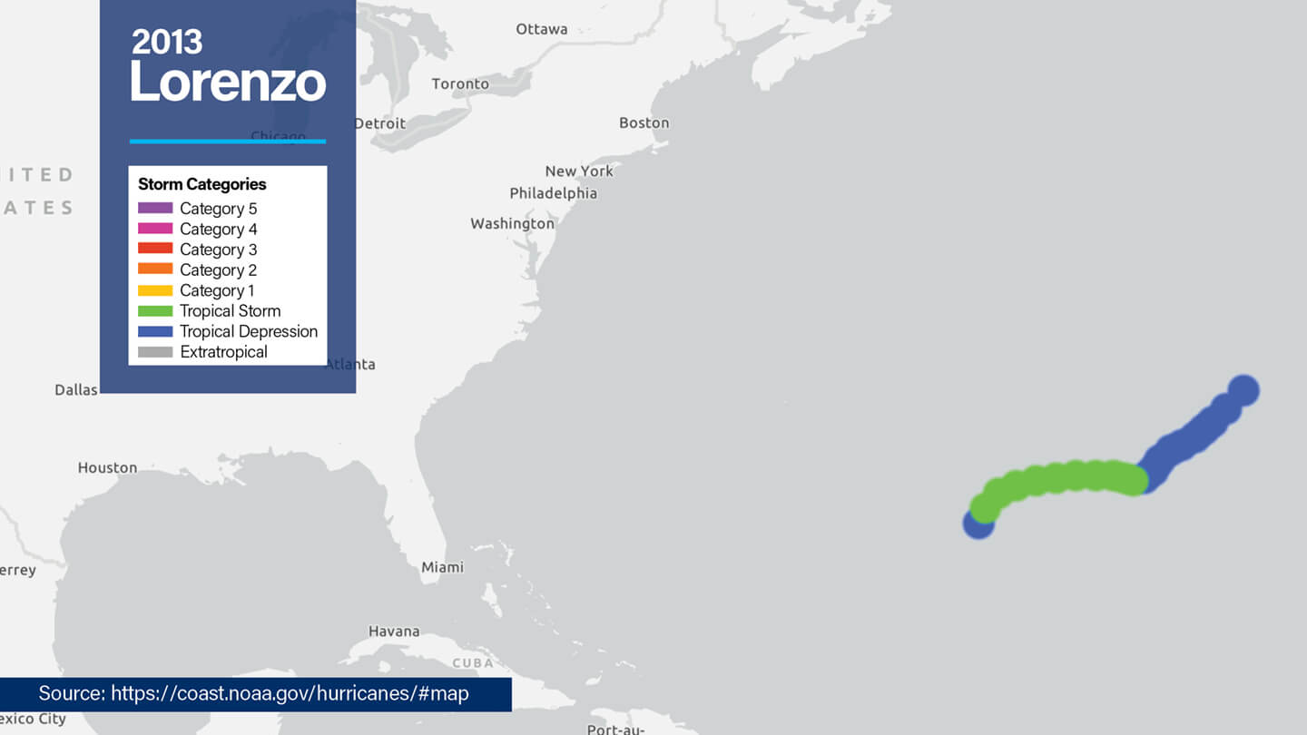
- Formation: 2013 Tropical Storm Lorenzo, a brief storm in the Atlantic from October 21 to October 24, 2013, formed from a tropical wave interacting with upper-level troughs. Its peak sustained wind speed was 52 mph (45 knots), occurring in cooler waters with high vertical wind shear, with a central pressure of 1000 millibars.
- Impact: This iteration of Lorenzo remained in open waters with no direct land interactions.
Hurricane Lorenzo (2019)
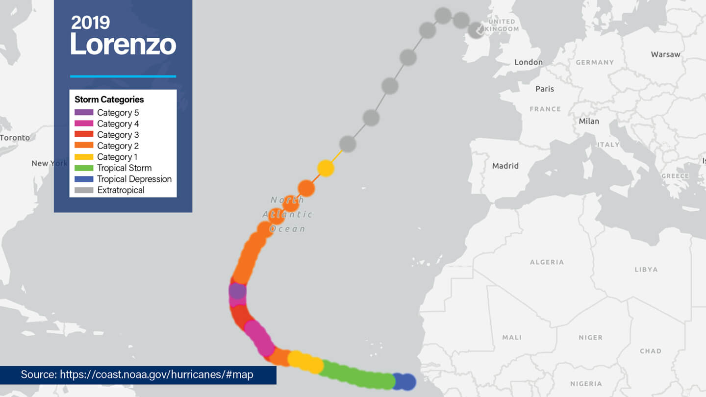
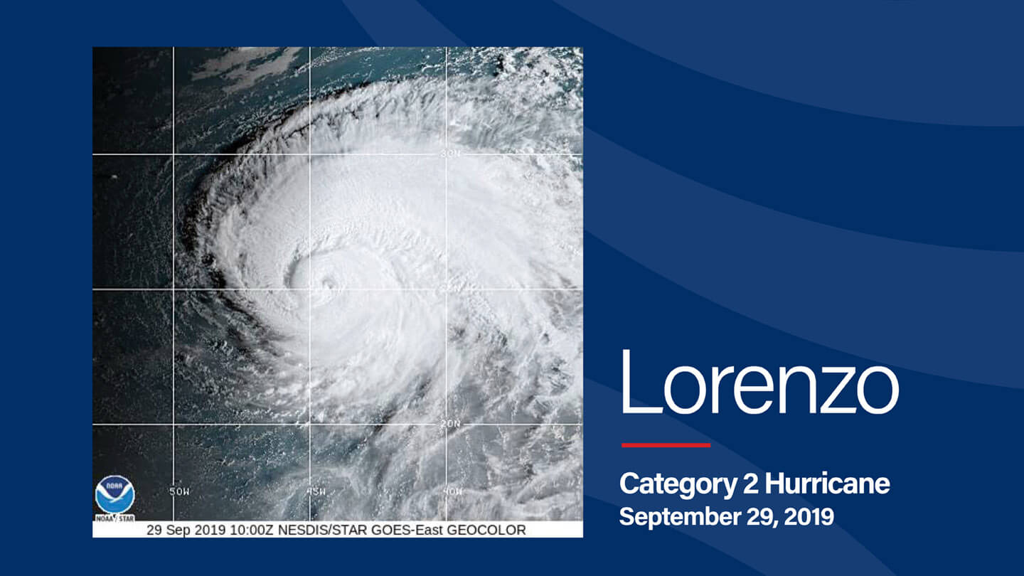
- Formation: 2019 Hurricane Lorenzo set historical benchmarks, becoming the easternmost and northernmost Atlantic Category 5 hurricane recorded in modern history. Forming from a tropical wave off Africa, it intensified dramatically over central Atlantic waters, peaking at 160 mph sustained winds (140 knots) and a minimum central pressure of 925 millibars near September’s end.
- Impact: Though its strongest phase avoided landfall, Lorenzo delivered hurricane-force winds to parts of the Azores and post-tropical storm impacts in Ireland.
Lorenzo Storm’s Meteorological Insights
| Storm | Year | Peak Wind Speeds | Rainfall/Flooding | Storm Surge/Extratropical Effects |
|---|---|---|---|---|
| Tropical Storm Lorenzo | 2001 | 40 mph (35 knots) | None recorded | Merged with a front; no recorded surge impacts |
| Hurricane Lorenzo | 2007 | 80 mph (70 knots) | Up to 12 inches in parts of Mexico | Coastal flooding and localized landslides in Veracruz and Puebla regions |
| Tropical Storm Lorenzo | 2013 | 52 mph (45 knots) | None recorded | Reamined in open waters; minimal influence on coastlines |
| Hurricane Lorenzo | 2019 | 160 mph (140 knots) | Minimal, with most rainfall occurring in Ireland at just above 1 inch | Azores experience disruptive wind-driven waves; later extratropical storms impacted Ireland |
Factors Influencing Lorenzo’s Development
Tropical storms like Lorenzo rely heavily on environmental conditions for their formation and intensification. These factors include:
- Sea Surface Temperatures (SSTs): Higher SSTs, such as those seen during Lorenzo’s formation in 2019, provide essential thermal energy that fosters storm development.
- Wind Shear: The 2013 Lorenzo struggled due to moderate wind shear, preventing any substantial intensification.
- Atmospheric Moisture: Adequate humidity levels promote sustained convection, critical for hurricane formation, as in 2007 Hurricane Lorenzo’s rapid intensification.
Each factor interacts uniquely with every storm, resulting in distinct patterns of development and behavior.
Getting Ready for Tropical Storm Lorenzo/Hurricane Lorenzo
Individuals and Families
Residents in flood-prone areas should be aware of flood zones, identify evacuation routes, and keep waterproof backups for essential documents. To stay connected during power outages, stock battery-powered radios or satellite communication devices.
Businesses
Businesses, especially those in coastal regions or relying on waterways, should install backup power sources and assess the resilience of their IT systems. Additionally, businesses should review insurance plans to ensure coverage for hurricane-related risks to minimize potential losses. Flood insurance is typically separate from a normal insurance policy, so be sure to verify whether your policy includes it or if a separate plan is needed.
Local Governments
Local governments should prioritize reinforcing infrastructure by maintaining water drainage systems in vulnerable areas before hurricane season. Additionally, they should organize emergency shelters equipped to safely house displaced residents for extended periods.
FAQs About Lorenzo
Was Hurricane Lorenzo 2019 retired?
No, despite its iteration in 2019, “Lorenzo” remains active on storm-naming lists managed by the World Meteorological Organization (WMO).
What was Hurricane Lorenzo 2019’s path?
2019 Hurricane Lorenzo originated off West Africa, tracked across central/eastern Atlantic waters, affected the Azores, and later brought post-tropical conditions to Ireland.
When did Hurricane Lorenzo 2019 hit?
Hurricane Lorenzo in 2019 reached Category 5 strength on September 29, 2019, and impacted the Azores on October 2, 2019.
What are the long-term effects of hurricanes like Lorenzo?
Beyond immediate flooding or wind damage, hurricanes often reshape coastlines, disrupt agricultural yields, and necessitate substantial financial expenditures for infrastructure recovery.
Why do some storms, like 2013 Tropical Storm Lorenzo, weaken in dry conditions?
Dry air inhibits the organization of a storm’s core by limiting the moisture required to sustain convection, as observed in the 2013 tropical storm.
What was Hurricane Lorenzo’s peak intensity in 2019?
Hurricane Lorenzo reached a peak intensity of 160 mph (140 knots) as a Category 5 hurricane, with a minimum central pressure of 925 mb.
When did Hurricane Lorenzo make landfall in 2007?
Hurricane Lorenzo in 2007 made landfall near Tecolutla, Mexico, on September 28, 2007, as a Category 1 hurricane.
Why is Hurricane Lorenzo (2019) considered historic?
Its distinction as the easternmost Category 5 hurricane in the Atlantic and its enormous geographic impacts on swells made it a truly unique storm.
Watching for Tropical Storm Lorenzo and Hurricane Lorenzo
Storms like Lorenzo show how unpredictable tropical cyclones can be. Some are weak systems. Others grow into powerful hurricanes. Some shift paths unexpectedly, while others intensify rapidly with little warning. This is why everyone should have a response plan and prepare well in advance. As conditions evolve, timely decisions can make all the difference in protecting lives, property, and communities.
For organizations seeking expert support before, during, and after major storms, Tidal Basin offers the guidance and resources needed to navigate disaster preparedness and recovery with confidence.
