Tropical Storm Karen and Hurricane Karen have appeared multiple times in Atlantic storm history with a range of impacts and behaviors.
While some were significant and others minimal, these storms offer valuable lessons on naming conventions, forecasting challenges, and the importance of preparedness. This article explores the history of storms named Karen, their behavior, and their contributions to meteorology and disaster readiness.
Historical Overview of Storms Named Karen
The name Karen has been assigned to multiple tropical systems in the Atlantic, each contributing unique lessons in forecasting and preparedness.
Tropical Storm Karen (1989)
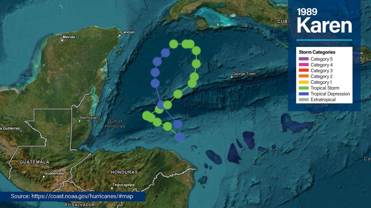
- Formation & Behavior: Developed southwest of Cuba on November 30 and reached peak intensity with sustained winds near 60 mph; it remained over water and weakened by December 4.
- Impact: Brought heavy rainfall to the Isle of Youth and western Cuba, produced a tornado, but caused minimal damage and no fatalities.
Tropical Storm Karen (1995)
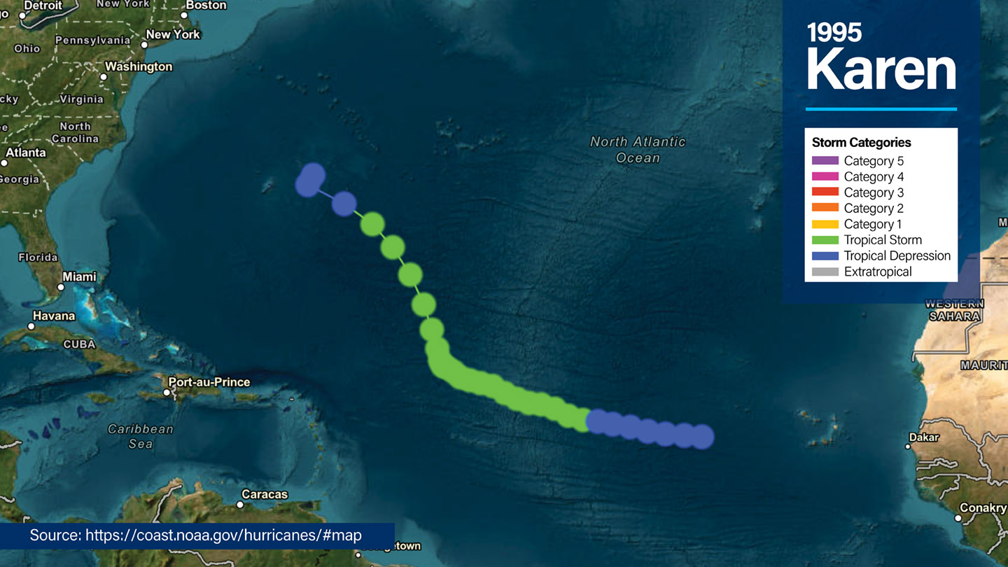
- Status: A weak Atlantic system that formed east of the Lesser Antilles and was later absorbed by Hurricane Iris without significantly affecting land.
- Impact: No landfall or damage reported.
Hurricane Karen (2001)
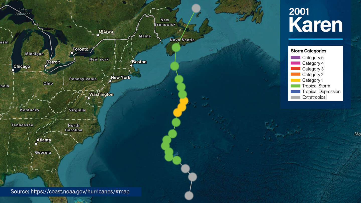
- Formation & Peak: Formed in the central Atlantic and reached Category 1 intensity
- Path & Impact: Passed near Bermuda, causing rough surf and minor coastal flooding; did not make landfall on heavily populated areas.
Hurricane Karen (2007)
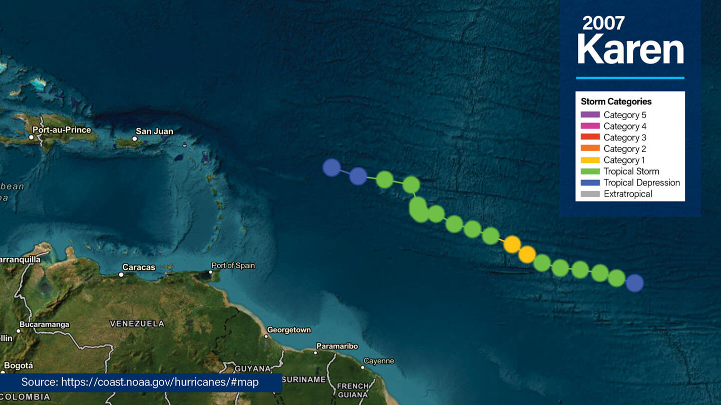
- Formation & Intensity: Originated from a tropical wave in late September, briefly intensified into a Category 1 hurricane with about 75 mph (65 knots) winds.
- Path & Impact: Remained over the central Atlantic, dissipating east of the Leeward Islands without affecting land.
Tropical Storm Karen (2013)
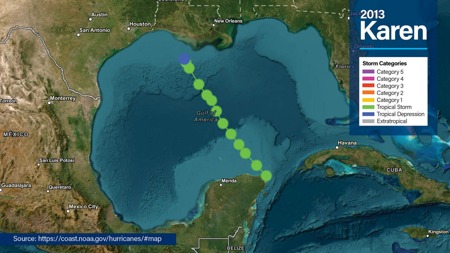
- Formation & Path: Formed over the Gulf Coast on October 3, made landfall as a trough, then became a nor’easter off the U.S. East Coast.
- Impact: Triggered coastal flooding in the Gulf and delivered heavy inland rain up to about 11 in (such as in Harrisburg, PA); damage was limited and no fatalities occurred.
Tropical Storm Karen (2019)
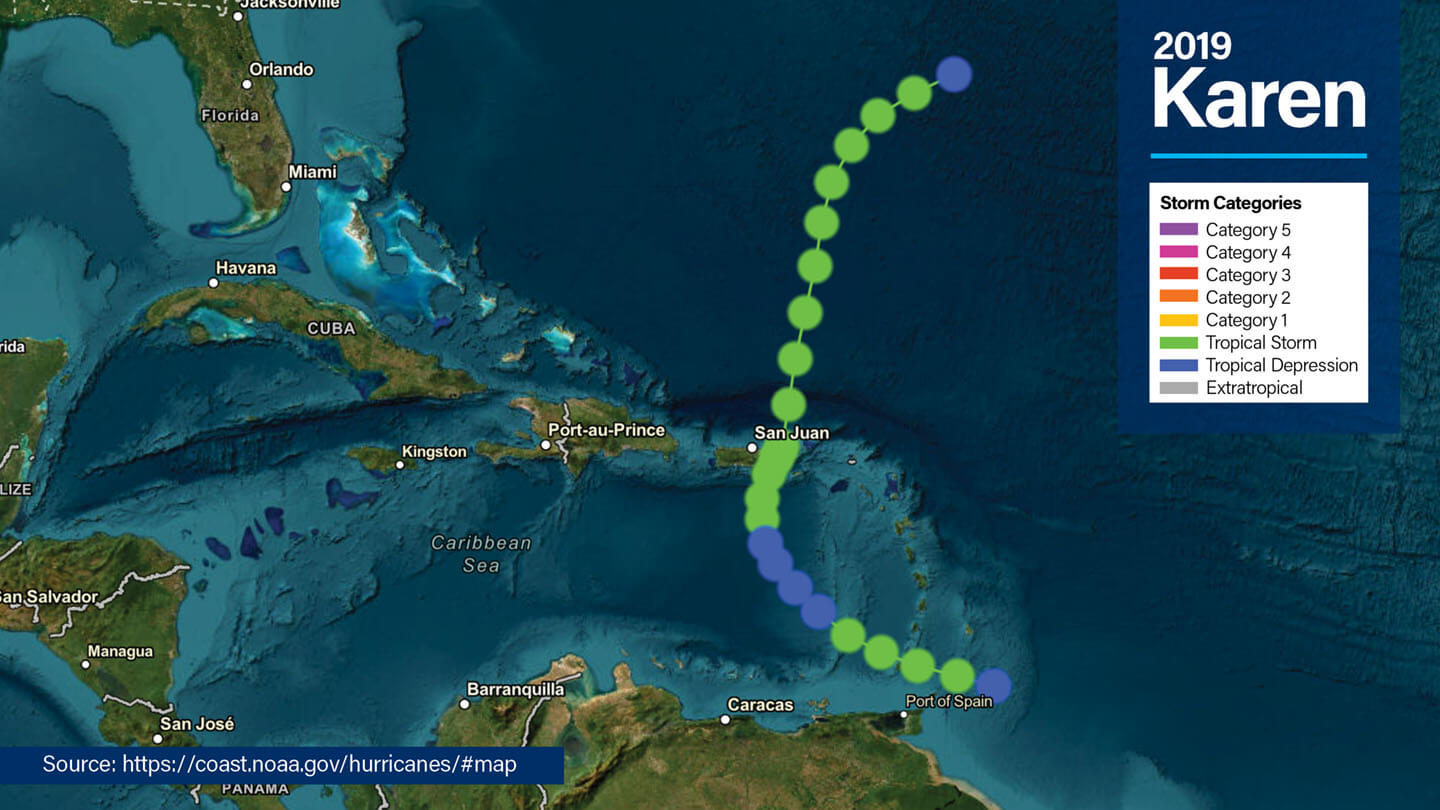
- Formation & Behavior: Developed in the Atlantic, tracked erratically and briefly threatened Puerto Rico before dissipating.
- Impact: Brought gusty winds and rainfall to parts of the Caribbean without causing widespread damage.
| Year | Classification | Key Notes |
| 1989 | Tropical Storm Karen | Heavy rainfall in Cuba; no major damage or landfall |
| 1995 | Tropical Storm Karen | Absorbed without land impact |
| 2001 | Hurricane Karen (Cat 1) | Passed near Bermuda; minor coastal effects |
| 2007 | Hurricane Karen (Cat 1) | Stayed offshore east of the Leeward Islands |
| 2013 | Tropical Storm Karen | Coastal flooding and nor’easter; limited impact inland |
| 2019 | Tropical Storm Karen | Erratic path; light gusts and rain in Puerto Rico region |
Preparedness Lessons from Storms Named Karen
While storms named Karen have varied in strength, each of them gives us the same preparedness lessons:
- Early readiness matters. Even storms with low intensity can evolve rapidly, making early planning critical.
- Tropical storms are not harmless. Karen systems show that weaker storms can still cause heavy rain and localized flooding.
- Clear communication saves lives. Effective public communication and coordination during storm seasons reduces risks and improves safety outcomes.
Storm Naming Conventions Explained
When Does a Storm Get Named?
A storm is officially given a name once it reaches tropical storm status, meaning its sustained winds have reached at least 39 miles per hour. This threshold marks the point at which a storm’s potential impact becomes significant enough to warrant easier identification and communication.
The names assigned to these storms are pre-selected from rotating lists maintained by the World Meteorological Organization (WMO). These lists are region-specific and are reused in cycles, typically every six years, unless a name is retired due to the storm’s severity.
By assigning names, meteorologists and emergency agencies can avoid confusion, especially when there are multiple storms active at the same time.
Why is Naming Tropical Storms Important?
The process of naming tropical storms helps with clear communication during hurricane seasons. Storm names make it easier for meteorologists, emergency managers, and the general public to track and discuss weather systems and their developments.
Without names, storms might be referred to by geographic coordinates or technical identifiers, which can be confusing and unwieldy, especially for the public. A name like “Karen” is far easier to remember and allows for consistent messaging in warnings and updates.
This clarity becomes especially critical when multiple storms are active simultaneously, helping to prevent miscommunication and ensure that essential safety information reaches those in affected areas.
When Are Storm Names Retired?
Not all storm names are reused indefinitely. If a storm is particularly devastating, causing significant destruction or loss of life, its name is permanently retired out of respect for those affected and to avoid future distress.
Retiring a name both makes sure that it is not reused and acknowledges the historical significance of the storm. For example, names like Katrina (2005) and Harvey (2017) were retired after they caused catastrophic damage on communities in their path.
The decision to retire a name is made by the WMO, based on the storm’s severity and its aftermath. Once a name is retired, it is replaced with a new one to maintain the integrity of the rotating lists.
Has the Name Karen Been Retired?
Despite being assigned to multiple Atlantic storms over the years, the name Karen has not been retired. Why not?
Unlike names such as Katrina, Harvey, or Maria, which were permanently removed from the World Meteorological Organization (WMO) lists due to their catastrophic impacts, none of the Karen-named storms have caused significant loss of life or widespread destruction.
While some versions of Karen brought heavy rain, rough surf (dangerous coastal wave activity) or temporary concerns, none reached the threshold that prompts retirement.
As a result, Karen remains on the WMO’s rotating list of Atlantic storm names and is eligible for future use. Unless a future Tropical Storm or Hurricane Karen causes major devastation, the name will continue to appear in upcoming hurricane seasons.
Frequently Asked Questions About Tropical Storm/Hurricane Karen
Was Tropical Storm Karen in 2019 destructive?
No, the 2019 storm was notable for its erratic path but did not cause significant damage.
Can Karen still appear as a storm name?
Yes, the name Karen has not been retired and remains part of the WMO’s official list.
How many times has the name Karen been used for storms?
Karen has been six times since its introduction for tropical storms in the Atlantic and other regions. Most instances have been relatively mild in terms of impact.
What makes a tropical storm become a hurricane?
A tropical storm becomes a hurricane when its sustained wind speeds reach 74 mph (119 km/h). Further intensification leads to stronger hurricane classifications.
How can I prepare for a tropical storm like Karen?
Preparation includes assembling an emergency kit, securing your home, staying informed through weather updates, and following evacuation orders if issued.
Can storms like Karen change their path?
Yes, tropical storms are known for their unpredictability, and they can change their paths quickly, which is why accurate forecasting and monitoring are critical.
What role do forecasting models play in storm tracking?
Forecasting models analyze data to predict a storm’s path, intensity, and potential impact. These models, including spaghetti models, are vital for issuing timely warnings and preparing affected communities.
Understanding Past Karen Storms for Future Preparedness
The history of storms named Karen offers valuable insights into meteorology, preparedness, and storm behavior. Whether they bring lessons in forecasting or remind us of the need for readiness, these storms highlight the complexity of tropical systems.
Stay informed and stay prepared. Keep an eye on reliable sources like weather apps, news updates, and official alerts to track upcoming storms. Make sure you have an emergency plan in place, stock up on essentials, and secure your home to stay safe during hurricane seasons. Being proactive can make all the difference!
