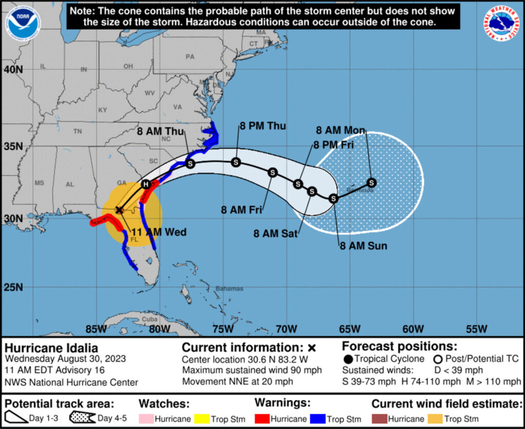
Hurricane Idalia made landfall early this morning near Keaton Beach in Florida’s Big Bend as a Category 3 storm with maximum sustained winds of 125 mph and even higher gusts. It briefly intensified to a Category 4 storm earlier this morning but lowered back to a high-end Category 3 hurricane before making landfall.
Idalia is the strongest storm to make landfall in the Big Bend region in more than 125 years. According to the National Hurricane Center, Idalia’s landfall strength and storm surge could reach once-in-a-lifetime levels in the region, which could be swamped by a surge of up to 16 feet.
Idalia is the third hurricane to make landfall in Florida in the last 12 months, following Hurricane Ian in September 2022 and Hurricane Nicole in October 2022.
Gov. Ron DeSantis urged Florida residents to heed emergency officials’ warnings to take cover. “You don’t want to be messing around with these winds. There’s going to be things flying all over the place,” he said at a news conference Wednesday morning.
As of 10:30 a.m. ET, there are about 268,280 Florida customers from the Big Bend region in the dark according to poweroutage.us, which is about 56% of all customers in that region.
Earlier, a tornado watch went into effect for nearly 12 million people across central and northern Florida and southeast Georgia until 3 p.m. ET, Wednesday, August 30th, as conditions continue to deteriorate. Most Gulf coast counties are already experiencing extreme storm surge, with the worst expected to be 12-16 feet between the Wakulla-Jefferson County line to Yankeetown. The vulnerable island of Cedar Key is within that same region and already had its water level record shattered with 9 feet of storm surge, and that number is expected to continue rising.
The storm will continue across North Central Florida and into Georgia and South Carolina today and tomorrow. Here are a few tips from Ready.gov on how you can stay safe during a hurricane:
- Stay Informed: Pay attention to emergency information and alerts.
- Dealing with the Weather:
- Determine how best to protect yourself from high winds and flooding
- Take refuge in a designated storm shelter or an interior room for high winds.
- Go to the highest level of the building if you are trapped by flooding. Do not climb into a closed attic, as you may become trapped by rising flood water.
- Do not walk, swim or drive through flood waters. Turn Around. Don’t Drown! Just six inches of fast-moving water can knock you down, and one foot of moving water can sweep your vehicle away.
- Returning Home After a Hurricane:
- Pay attention to local officials for information and special instructions.
- Be careful during clean up. Wear protective clothing, use appropriate face coverings or masks if cleaning mold or other debris. People with asthma and other lung conditions and/or immune suppression should not enter buildings with indoor water leaks or mold growth that can be seen or smelled, even if these individuals are not allergic to mold. Children should not help with disaster cleanup work.
- Do not touch electrical equipment if it is wet or if you are standing in water. If it is safe to do so, turn off electricity at the main breaker or fuse box to prevent electric shock.
- Do not wade in flood water, which can contain dangerous pathogens that cause illnesses. This water also can contain debris, chemicals, waste and wildlife.
- Underground or downed power lines also can electrically charge the water.
- Save phone calls for emergencies. Phone systems often are down or busy after a disaster. Use text messages or social media to communicate with family and friends.
- Document any property damage with photographs. Contact your insurance company for assistance.
For more tips and information, visit our Hurricane Resource Center.
Remember to heed all safety warnings from emergency professionals and please stay safe!


