Tropical Storm Chantal and Hurricane Chantal were possible names to headline weather news this year. With Tropical Storm Chantal now having formed and dissipated, we can explore more about the name “Chantal,” the third tropical storm of the Atlantic hurricane season.
In this article, we examine previous tropical storms and hurricanes named Chantal and offer insights and lessons to better prepare for future storms.
Whether you’re tracking the forecast or reviewing emergency plans, staying informed is your first line of defense.
The History and Significance of Tropical Storms and Hurricanes Named Chantal
The name “Chantal” has been assigned to several tropical systems over the years, each with unique formations, paths, and impacts.
Below is an overview of each “Chantal” storm that has formed in the Atlantic, along with details on its impacts and the areas affected along its path.
Hurricane Chantal in 1983
This tropical system began as an area of low pressure southeast of Bermuda. By September 10, reconnaissance missions reported strong winds at 40 mph (35 knots) and a central pressure of 1006 mb, leading to its classification as Tropical Storm Chantal.
It quickly gained strength, reaching hurricane status with winds of 75 mph (65 knots) within 24 hours. While it didn’t directly strike land, its interaction with westerly troughs illustrated how environmental conditions can intensify tropical systems in a short period.
Hurricane Chantal in 1989
Chantal became the first hurricane of the 1989 Atlantic season, strengthening over the Gulf Coast before making landfall near High Island, Texas.
With peak winds of 94 mph (82 knots) right before landfall, this hurricane tested emergency preparedness plans along the Texas coast. Despite being a Category 1 storm, its heavy rains and winds caused substantial power outages and coastal flooding.
Tropical Storm Chantal in 1995
This Chantal storm formed east of the Lesser Antilles and followed an evasive route, passing north of Puerto Rico and steering clear of land.
While it strengthened to a tropical storm with winds of 70 mph (60 knots) at its peak, it lost intensity over the North Atlantic.
Here, it transitioned into an extratropical system, a storm that derives energy from temperature differences in the atmosphere rather than warm ocean waters.
Tropical Storm Chantal in 2001
The 2001 Tropical Storm Chantal was notable for its disorganized but persistent cycle. It originated near Africa and became a tropical storm on August 17 in the Atlantic before skirting through the Caribbean.
It weakened due to high wind shear but re-intensified at the last moment before crossing the Mexico-Belize border with winds of 70 mph (60 knots). If it stayed over water for another hour or so, it might have reached hurricane status before making landfall.
Tropical Storm Chantal eventually weakened to a depression on August 22.
Tropical Storm Chantal in 2007
A short-lived tropical storm, 2007’s Chantal quickly developed in late July over waters off the United States East Coast.
With peak winds of 52 mph (45 knots), Chantal followed a northeast path, becoming extratropical and intensifying over the Atlantic before merging with another system.
Although brief, its evolution provided valuable meteorological data on storm decay and transformation.
Tropical Storm Chantal in 2013
Tropical Storm Chantal in 2013 formed unusually early in the season and traveled through the Lesser Antilles.
Despite reaching peak winds of 63 mph (55 knots), it struggled with vertical wind shear throughout its lifespan. It dissipated south of Hispaniola but left behind significant rainfall and diminished infrastructure in parts of the Caribbean.
Tropical Storm Chantal in 2019
This iteration of Chantal was characterized by a quick transition from a low-pressure system to a tropical storm. It peaked at 40 mph (35 knots) in the North Atlantic before reverting to an open-wave system.
Chantal’s remnants lingered for several days before merging with another low-pressure system.
Tropical Storm Chantal in 2025
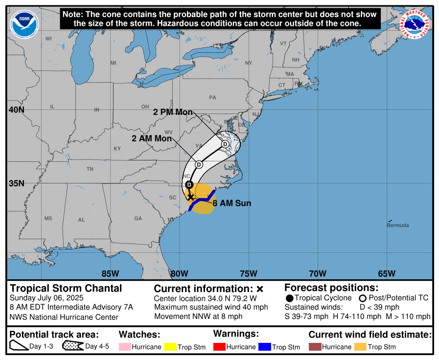
Tropical Storm Chantal in 2025 initially struggled to gain strength due to wind shear but eventually intensified overnight before making landfall on July 6. The storm brought estimated winds near 60 mph (about 50 knots) and a pressure of 1002 mb.
Chantal made landfall along the coast of the Carolinas, bringing an estimated 4 to 6 inches of rainfall. It moved along the East Coast until it weakened into a depression over parts of Northern Virginia, Pennsylvania and New Jersey.
How Tropical Storm and Hurricane Chantal Could Form
Tropical storms form through a combination of warm ocean temperatures, low wind shear, and favorable atmospheric conditions.
A tropical wave or disturbance is often where storm development begins. Over warm waters, this disturbance can grow into a tropical depression, generating thunderstorms and convection.
If conditions remain favorable, the system intensifies into a tropical storm, earning its name, and potentially becomes a hurricane when sustained winds exceed 74 mph. Favorable steering currents and atmospheric patterns usually dictate whether the storm strengthens further or weakens.
While it will not affect this year’s Chantal, historical data suggests that past storms named Chantal often intensify quickly but are susceptible to westerly shear and dry air interference, which can weaken them rapidly.
Hurricane Preparedness Tips for Local Leaders
While we can’t control the weather, we can control our preparedness.
Enhancing resilience during hurricane season requires collective efforts, including personal preparation and support from local governments.
- Strengthen Infrastructure: Reinforce key facilities like hospitals, fire stations, and emergency management centers to withstand storm impacts.
- Provide Clear Emergency Alerts: Use SMS alerts, local radio, and social media to share critical updates on weather conditions and evacuation routes.
- Conduct Community Drills: Organize annual simulations in schools and workplaces to familiarize residents with safety protocols.
- Enhance Drainage Systems: Improve drainage networks in flood-prone areas to prevent urban flooding during heavy rainfall.
- Support Vulnerable Populations: Create tailored evacuation plans and transportation networks for seniors, individuals with disabilities, and other at-risk groups.
Preparedness thrives when communities are involved. Local leaders can also initiate disaster-readiness workshops, distribute emergency kits, and encourage grassroots organizations to play active roles in spreading awareness.
Staying Alert for Tropical Storm Chantal
While no two storms are identical, understanding the historical behavior of storms gives us a better perspective on how they may act in the future. While Tropical Storm Chantal never strengthened into a hurricane, preparation and vigilance are the keys to safety for future storms.
To help you stay ahead this hurricane season, visit our Hurricane Resource Center. There, you’ll find tools, safety tips, and preparedness guides to protect your home and community.
FAQs About Chantal
How are storm names chosen?
The World Meteorological Organization (WMO) maintains a rotating list of storm names for each region. If a storm causes significant damage or fatalities, its name is retired and replaced.
What is the usual peak time for storms like Chantal?
The Atlantic hurricane season peaks between mid-August and late September, a timeframe when conditions are most favorable for storm development.
How do storms like Chantal develop?
Storms form from disturbances such as tropical waves or low-pressure systems. Warm water, moist air, and low wind shear create an environment where storms can intensify.
How does wind shear impact storm strength?
High wind shear tears apart a storm’s structure, limiting its ability to organize and grow. Low shear, on the other hand, allows storms to strengthen efficiently.
Can storms like Chantal intensify quickly?
Yes, some systems, known as “rapid intensifiers,” can strengthen dramatically when conditions like warm waters and low wind shear are optimal.
What is the role of reconnaissance planes in storm tracking?
Aircraft, known as “Hurricane Hunters,” fly into storms to measure critical factors like wind speeds, air pressure, and moisture content. These measurements help forecasters predict storm intensity and track its path.
How can I track active storms?
The National Hurricane Center (NHC) and similar agencies provide updates on active storms using satellite imagery, aircraft reconnaissance, and advanced weather models.
How can I protect my home before a storm?
Board up windows, clear gutters, secure outdoor furniture, and place sandbags around entry points to minimize damage.
Is evacuation always necessary?
Not always. Pay attention to official instructions specific to your area. Evacuations are typically advised for coastal zones or regions prone to severe flooding.


