The name Pablo has made several appearances in Atlantic hurricane history, listed on the World Meteorological Organization’s (WMO) rotating list of storm names. For the 2025 Atlantic hurricane season, it’s the 16th name on the roster, coming after Olga and before Rebekah.
Any storm named Pablo in 2025 would be its own, unrelated system, but looking back at previous storms with the same name gives us helpful perspective. These past events not only offer meteorological insight but also remind us of the importance of being prepared for what future storms may bring.
Overview of Storms Named Pablo
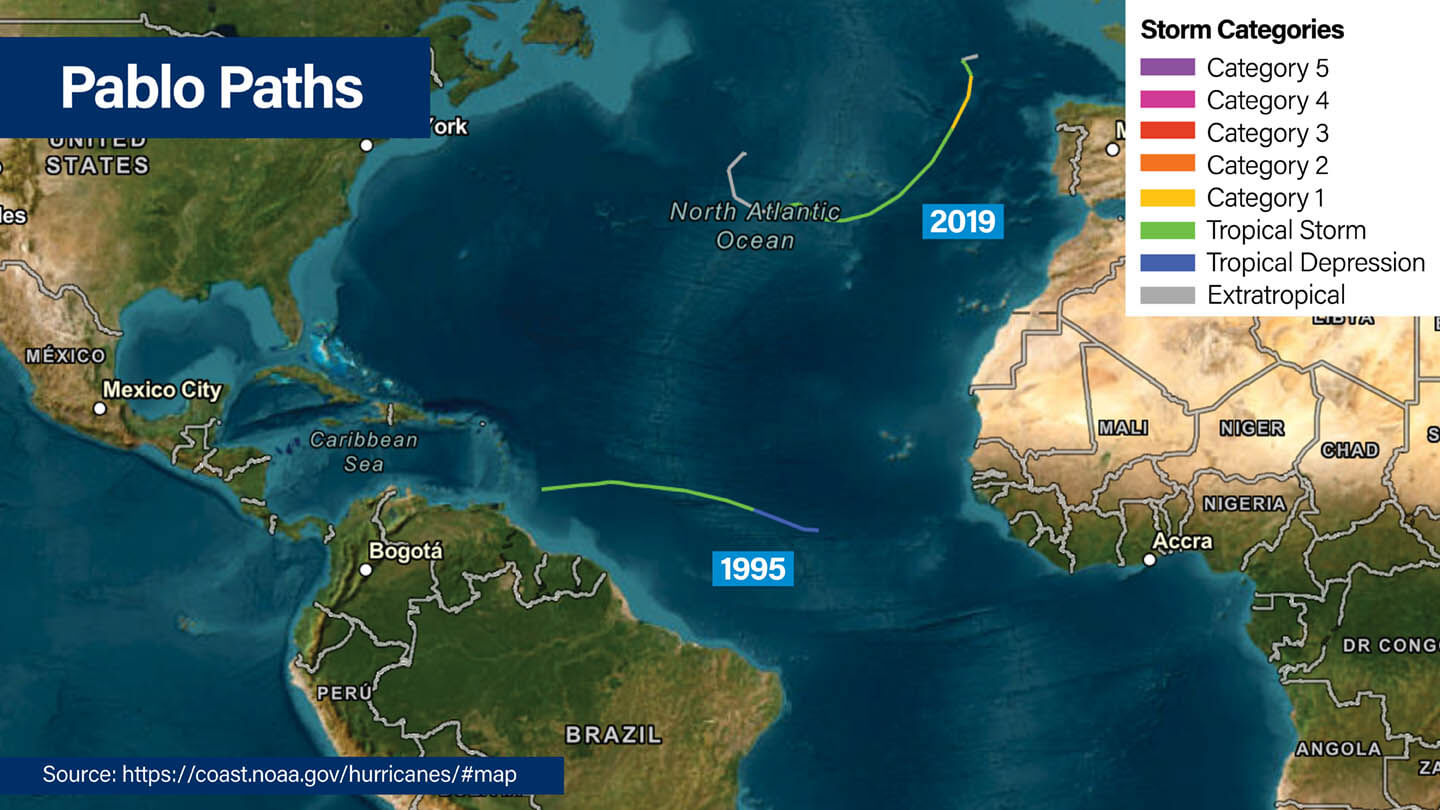
Tropical Storm Pablo (1995)
- Storm Category: Tropical Storm
- Formation: October 4, 1995, from an African tropical wave
- Peak Intensity: 50 mph sustained winds (43 knots) on October 6 with a minimum pressure of 994 mb
- Dissipation: October 8, 1995, due to strong vertical wind shear
- Location and Path: Moved westward across the tropical Atlantic, dissipating approximately 135 nautical miles east-southeast of Barbados
- Impact: No land impacts or casualties; served as a forecasting challenge for meteorologists
1995 Tropical Storm Pablo maintained relatively consistent intensity throughout its brief existence, with sustained winds near 52 mph (45 knots) for most of its lifecycle. The storm encountered hostile atmospheric conditions, including strong vertical wind shear, which prevented further development and ultimately led to its dissipation before reaching the Lesser Antilles.
Hurricane Pablo (2019)
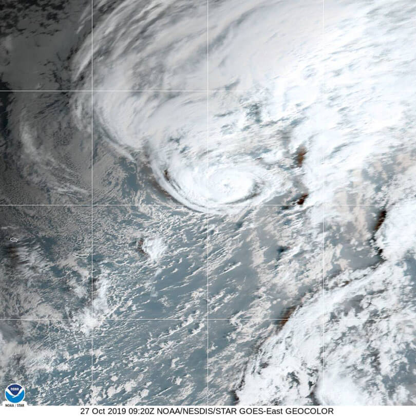
Hurricane Pablo in 2019 was a record-breaker, forming farther north and east than any other hurricane ever recorded in the North Atlantic. Its development showed that tropical systems can take shape even in areas that are usually considered unfavorable for hurricanes.
- Storm Category: Category 1 Hurricane
- Formation: October 25, 2019, from a non-tropical baroclinic low
- Peak Intensity: Sustained winds of 80 mph (70 knots) with a minimum pressure of 977 mb
- Dissipation: October 28, 2019, after transitioning back to extratropical
- Location and Path: Formed over the northern Atlantic, passed near the eastern Azores
- Impact: Historic formation location; no significant damage reported
In 2019, Hurricane Pablo went through a striking transformation, starting as a baroclinic low (a low-pressure system fueled by clashing warm and cold air), shifting into a subtropical storm, then strengthening into a tropical storm, and eventually becoming a hurricane. It reached its peak on October 27, but cooler waters and stronger wind shear soon weakened the system, pushing it into an extratropical phase.
Factors Behind Pablo’s Storm Development
Ocean Temperatures
Sea surface temperatures (SSTs) played very different roles in each Pablo. The 1995 storm formed over waters that were just warm enough for October in the tropical Atlantic.
By contrast, Hurricane Pablo in 2019 developed over cooler waters in the northern Atlantic, showing that storms can still form outside the usual warm-water zones when other conditions come together.
Atmospheric Conditions
Wind shear shaped both storms in important ways. In 1995, increasing vertical wind shear stopped Pablo from strengthening and led to its quick weakening.
In 2019, Pablo first grew in a low-shear environment but later ran into stronger upper-level winds that helped push it into an extratropical system.
Pressure Differences
The two storms formed through very different processes. Pablo in 1995 followed the more typical tropical path, with thunderstorms organizing over warm waters.
Pablo in 2019, however, started more like a mid-latitude system before gradually taking on tropical features through a complex transition.
What Pablo’s History Reveals About Storm Formation
Cape Verde Origins
Pablo 1995 fit the pattern of Cape Verde–type storms, which form from waves moving west from Africa. These systems often take shape in the peak months of hurricane season when conditions in the Atlantic favor development.
Transition from Non-Tropical Systems
Pablo 2019 showed how storms that don’t start in the tropics can still transform into hurricanes. This process, called tropical transition, happens only when the right mix of moisture, upper-level winds, and sea temperatures are in place.
Seasonal Timing
Both Pablo storms formed in October, late in the hurricane season. This period often brings shifting weather patterns as the season winds down toward its official end on November 30.
Regional Impacts of Tropical Storm Pablo (1995) and Hurricane Pablo (2019)
Caribbean Basin
Neither Pablo storm caused major damage in the Caribbean, but the 1995 Tropical Storm Pablo prompted tropical storm watches for parts of the Lesser Antilles. Even though the storm stayed offshore, it brought gusty winds, rough seas, and heavy rainfall to some islands, showing how quickly conditions can change and the importance of staying alert.
Atlantic Shipping Routes
Both storms impacted maritime operations in the Atlantic. The 1995 system led to shipping advisories, while Hurricane Pablo in 2019 took an unusual northern track that created hazardous conditions in waters typically considered safer for navigation. It’s a reminder of the reach of these storms and the precautions mariners must take, even in seemingly safe waters.
European Waters
Hurricane Pablo in 2019 moved northeast toward European waters, showing that Atlantic storms can have effects far beyond the tropics. While it didn’t make landfall, its approach demonstrated the potential for Atlantic hurricanes to influence weather patterns and marine conditions in regions not normally associated with tropical systems.
How to Get Ready for Future Pablo Storms
What Individuals and Families Can Do
- Emergency Supplies
Keep a rotating stock of non-perishable food, water, medications, and batteries. Track expiration dates and replacement schedules so your supplies are always ready when needed. - Communication Plans
Set up multiple ways to stay in touch, such as satellite phones, two-way radios, and social media. Choose out-of-state contacts who can help share information if family members are separated during a storm. - Protecting Important Documents
Store copies of important documents in waterproof containers and cloud-based systems. Include insurance policies, identification documents, medical records, and financial information.
What Organizations Should Know
- Business Continuity Frameworks
Create business continuity plans that cover supply chain interruptions, employee safety, and alternative ways to keep operations running. Test these plans regularly with tabletop exercises to spot areas that could be improved. - IT Disaster Recovery Planning
Set up backup data storage, alternative communication networks, and remote work options so your organization can continue functioning during power outages or other disruptions.
What Local Governments Should Coordinate
- Emergency Operations Center (EOC) Preparations
Evaluate EOC readiness through regular assessments of equipment functionality, communication systems, and personnel training levels. - Interagency Collaboration
Build strong connections between federal, state, and local agencies to make sharing resources and coordinating responses smoother during emergencies.
Frequently Asked Questions About Tropical Storm and Hurricane Pablo
Has there ever been a Hurricane Pablo?
Yes, Hurricane Pablo occurred in 2019, achieving Category 1 status with maximum sustained winds of 80 mph (70 knots). This storm holds the record for the farthest north and east hurricane formation in the North Atlantic basin. The 1995 Pablo remained at tropical storm strength throughout its existence.
Where did Hurricane Pablo form?
Hurricane Pablo began as a non-tropical low-pressure system over the northern Atlantic in October 2019. It first appeared as a baroclinic low on October 22 and later developed into a subtropical storm before becoming a full tropical hurricane.
In contrast, Tropical Storm Pablo in 1995 formed from a tropical wave that moved off the African coast near the Cape Verde Islands.
When and where are hurricanes most likely to occur?
Atlantic hurricanes typically occur between June 1 and November 30, with peak activity from mid-August through late October. Most storms form in the tropical Atlantic, Caribbean Sea, or Gulf Coast, where warm ocean waters and favorable atmospheric conditions support development.
Why do tropical storms and hurricanes tend to form in the Caribbean or the Gulf Coast?
The Caribbean and Gulf Coast regions provide ideal conditions for tropical cyclone development, including consistently warm ocean waters, low wind shear, and atmospheric instability.
These areas also benefit from tropical wave activity moving westward from Africa, providing the initial disturbances necessary for storm formation.
What category was Hurricane Pablo in 2019?
Hurricane Pablo 2019 reached Category 1 status on the Saffir-Simpson Hurricane Wind Scale, with peak sustained winds of 80 mph (70 knots). The storm maintained hurricane intensity for approximately 12 hours before weakening due to cooler water temperatures and increasing wind shear.
How do meteorologists track storms like Pablo?
Meteorologists use multiple technologies to track tropical storms, including geostationary and polar-orbiting satellites, weather reconnaissance aircraft, surface weather stations, and ocean buoys.
Advanced computer models help predict storm movement and intensity changes, while Doppler radar provides detailed information about storm structure and precipitation patterns.
Can storms like Pablo form outside the traditional hurricane season?
While rare, storms can form outside the official hurricane season when atmospheric and oceanic conditions align favorably. Pablo 2019 formed in late October, near the end of the traditional season, while maintaining tropical characteristics despite cooler environmental conditions.
How can communities prepare for unexpected storms like Pablo?
Communities should maintain year-round preparedness through updated emergency plans, adequate supply stockpiles, and regular training exercises. Since storms like Pablo can develop with limited advance warning, having robust communication systems and pre-positioned resources becomes particularly important.
State and local governments developing comprehensive emergency management plans help communities respond effectively to unexpected storm events.
Maintaining Preparedness for the 2025 Hurricane Season
Atlantic hurricanes can form in a wide range of conditions and often follow unpredictable paths, making preparedness a key part of safety.
While no two storms are exactly alike, studying the history of storms named Pablo provides valuable guidance. While being informed and prepared can’t stop storms from occurring, it equips local and state governments, as well as communities, with the tools needed to respond effectively.
Stay prepared and protect what matters most. Connect with our Tidal Basin team today to safeguard operations and support a faster recovery before the next storm impacts your community.
